|
Geography
The current borders were consolidated by the British at the Union of South Africa cabinet meeting in 1910. Consequently, the natives had no say on these matters and were forced to abide by the rules and delegations instituted by the British colonists.
European powers such as Britain, France, Portugal, and many others participated in the Scramble for Africa and this was dated 1876-1914. The purpose of the scramble was for economic, political, and geographical advantages. One aspect to consider are the abundant natural resources such as gold, diamonds, coal, and platinum. The natural resources were concentrated in the north central-interior of South Africa. The video, South Africa's Geographic Challenge, on the right-hand side goes more in depth on the natural resources and discusses how they play a role in the South African economy (STRATFORvideo, 2013). While South Africa had a large supply of natural resources, challenges arose as South Africa had to regulate and and disperse the wealth to satisfy its population. One specific challenge was to "protect the extraction of natural sources in its interior" (STRATFORvideo, 2013). Although its resources are abundant, European powers sought to colonize Africa and exploit its natural resources for their own individual gain. Another challenge was to maintain sufficient employment. Because the natural resources were concentrated in the north-central interior, this is where many people went to get employment leaving other natives without good work. Lastly, South Africa must find ways to "disperse enough wealth to appease its populatio in areas that lack the source of natural resources" (STRATFORvideo, 2013). This goes back to the idea that work is naturally created near natural resources and that wealth should be distributed to other areas of the region in order to satisfy the needs and demands of its citizens. |
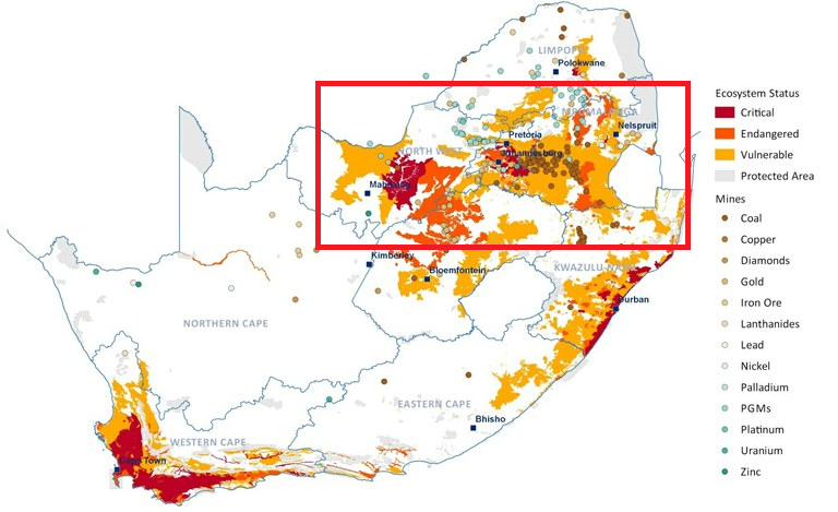
Mining and Ecosystem Status by MSCI ESG Research, South African National Biodiversity Institute
|
Climate
|
The majority of South Africa lies within the southern temperate zone, but its climate is more like the northern areas due to the surrounding waters. Temperatures differ between the east and west coasts due to the influence of the warm Mozambique Current and the cold Benguela Current ("South Africa", 2016)
South Africa is generally warm and sunny...but dry ("South African agriculture, 2012). Although it has some of the necessary components for agriculture, it lacks rain, which will be discussed more in depth in the section below. The video on the right-hand side states that South Africa has mild and pleasant climate ranging from 20°C-32°C in summers; and 10°C-20°C in winters" (ikenschool, 2015). In mountainous areas, the climate is cool whereas coastal areas experience hot and humid summers and dry winters. In desert areas like the Kalahari Desert, temperatures are high but not as high as some areas like the Sahel or or the Sahara. This is because the Kalahari has higher altitudes than the two deserts which means that the Kalahari has a cooler climate. The warmest month in Kalahari never exceeds 29°C whereas areas with lower altitudes such as the Sahel and the Sahara have experienced records of 38°C. South Africa receives summer rainfall brought by south-east trade winds. However, extremely low rainfall has resulted in formation of deserts in western and northern regions of the country like the Kalahari Desert. Due to unpredictable and inconsistent rainfalls, agriculture in South Africa is majorly restricted and this will be covered more in depth in the following section on agriculture. |

Kalahari in Namibia by Elmar Thiel used under CC BY-SA 3.0
|
Agriculture
|
Rainfall is highly unpredictable in large parts of the country and this has major restrictions on farming. The annual rainfall is about 46 cm in South Africa and to contrast, the world average is 86 cm ("South African agriculture", 2012). Because of the unpredictably of rainfall, farming is inconsistent and will suffer during droughts. This is an important point to consider because much of South Africa is dependent on agriculture for its wealth-the other being its mining industry.
Only 12% of South Africa can be used for crop production and of this 12%, only 22% of it is “high-potential arable land" ("South African agriculture", 2012). This is another important point to consider because it shows how much land is being used and how much land is not being used. The latter is an important statistic because it shows that 88% of South Africa is not being used for crop production. Other industries like mining or geographical challenges such as mountains could be the problem for crop production. The other important statistic is that only 22% of South Africa's land that can be used for crop pruduction is "high-potential arable" ("South African agriculture", 2012)." This means that the quantity and quality of South Africa diminishes in comparison to other countries that have better land, climate, and rain. |
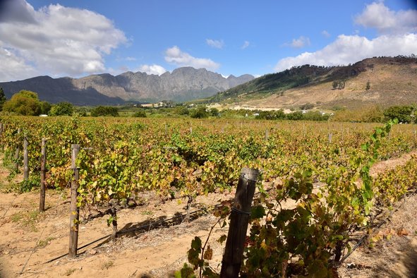
Franschhoek vineyard, Western Cape, South Africa by South Africa Tourism used under CC BY 2.0
|
Works Cited:
Gossipguy. (2015, August 05). Upland South Africa Savanna. Digital image]. Retrieved from https://commons.wikimedia.org/wiki/File%3AUpland_South_Africa_Savanna.jpg. Available under CC BY-SA 3.0
ikenschool. (2015, December 31). Retrieved from https://www.youtube.com/watch?v=duunr5Fycm0&t=79s
MSCI ESG Research, South African National Biodiversity Institute. (2013, October). "Mining and Ecosystem Status."
"South African agriculture." (2012, December 02). Retrieved from https://www.brandsouthafrica.com/investments-immigration/business/economy/sectors/agricultural-sector
Thiel, Elmar. (2003, January 01). Kalahari in Namibia. [Digital image]. Retrieved from https://en.wikipedia.org/wiki/Kalahari_Desert#/media/File:Kalahari_E02_00.jpg. Available under CC BY-SA 3.0
STRATFORvideo. (2013, July 18). Retrieved from https://www.youtube.com/watch?v=eP2EmglUeIQ
South African Tourism. (2015, April 12). Franschhoek vineyard, Western Cape, South Africa. [Digital image]. Retrieved April 11, 2017, from https://www.flickr.com/photos/south-african-tourism/20319683579
"South Africa." Worldmark Encyclopedia of Nations. Retrieved from http://www.encyclopedia.com/history/encyclopedias-almanacs-transcripts-and-maps/south-africa
